Tuesday, July 30, The Valdez Community Museum is actually housed in two separate buildings. The main building has a great deal of history of Valdez, a couple of antique Fire Trucks, information on the history of aviation in Valdez, of course information about the pipeline and how the town came to be. It is well laid out and does a good job of imparting a lot of the local history.


 |
| The video above shows a device created by Mr. Harold Plaster. |
The second building houses just the history of the Good Friday 1964 earthquake and resulting tidal wave that destroyed the waterfront area of the town of Valdez. They are quick to point out that Valdez proper was not destroyed, just the waterfront and dock area and two oil tank farms when they caught fire. Still more than 30 people lost their lives. Valdez had been built on water saturated soil. It had been built at the foot of the Valdez Glacier. In the spring time parts of Valdez would flood with the glacier melt off. The movement of the earthquake caused the water saturated soil to basically turn to liquid and this resulted in the waterfront and dock area sliding off into the sea. There is a very large miniature "map" of the old town of Valdez. A few pictures are shown below.


With the assistance of the federal government, Valdez relocated four miles further to the west on ground that had a good bedrock foundation. That is where the town is today. The buildings in the old town that were not moved to the new townsite were burned. Today you can drive through old town and see placards indicating which business was where. In the museum are multiple models showing the different parts of the old Valdez as it looked prior to the 1964 earthquake. There are also displays on the importance of aviation in the settling of Alaska. Several videos describing early bush pilots, their planes and where they flew to. Displays on the Exxon Valdez oil spill and what has been done to mitigate the damage and what damage that they are still finding today. A very well crafted museum. There were more photos taken of this beautiful location and the small boat harbor.


Dinner was at the Alaskan Halibut House. A drive-in styled restaurant. I had the Halibut Fish and Chips and Debbie had the Halibut Sandwich. It was good, but certainly not the best that we have had.
After dinner we went to Easy Freeze, a fish processing/shipping company I learned of through the parents of the owner, while we were in Fairbanks. We met Mike the owner and purchased 10 pounds of vacuum packed frozen Halibut to take home. The fish is caught in the Valdez waters by Cordovia Seafoods who process it and distributes it through outlets like Easy Freeze. Easy Freeze's main business is processing, filleting, cleaning packing, freezing and shipping the fish caught by customers on the charter boats. While ten pounds of halibut costs a few pennies, it costs almost as much to ship it to your home. Ten pounds ships FedEx Overnight for $110.
The day, July 31, started with breakfast at the Old Town Diner. This restaurant is in what looks to be a double wide modular type building. With one half of the length as kitchen and storage, while the other half is seating. Seating is picnic tables and you might find yourself sitting with a stranger, at least until you introduce yourself. The table behind us started being occupied by a young man from New Zealand who had just arrived. Pancakes, eggs and ham. It was a great breakfast served in courses. The pancakes came first, then the eggs and ham. Nice place, would be worth returning to.
After breakfast it was dump and flush the holding tanks, bring in the slides and hoist the jacks. Then to the Tesoro station for fuel, connect the Jeep and off toward Glennallen. With one road in, we were pretty familiar with this one. Through Keystone Canyon, over Thompson Pass and into Glennallen, 118 miles away. Through the same construction areas that we came through a couple days previously. In Glennallen, we continued north then east toward Tok, AK. The road to Glennallen is no picnic with pavement breaks, frost heaves and places of nice smooth pavement where you can go the speed limit to having to brake hard for the next set of bad pavement patches. From Glenallen to Tok, was just plain terrible. Frost heaves, pavement breaks and a wonderful 12 mile stretch of construction with pilot car that was a real treat. Other than road construction the vistas were mountains, glaciers, rivers and streams.


We arrived safely in Tok and decided that since we planned to go to breakfast the next day at the Sourdough Campground Cafe that we would just stay there. A back in site was assigned and soon we were hooked to utilities with the jacks down and slides out. This campground is forested and they do their best to have a good vegetation growth on both sides of the sites for privacy. They also have a communal fire pit and nightly activities which include a Sourdough Pancake toss. The winner gets a free breakfast the next morning.
 |
| Campfire circle at Sourdough Campground |
Debbie is the photographer for this update. She took pictures while I drove and tried to avoid the worst of the hazards.
This morning, August 1, 2019, breakfast was at the Sourdough Camp Cafe - Blueberry pancakes for me, buttermilk for Debbie, ham and eggs - just as good as the last time we were here, a month ago.
After breakfast we unhooked, brought in the slides, lifted the jacks and moved over to the dump station where both tanks were emptied, then we were on our way...to the gas station. We drove three miles to Three Bears Alaska Shell station and topped off the diesel, then we were on the road. Destination today was to be Destruction Bay, along Kluane Lake. But first we had a 90 mile drive to the Canadian Border crossing. The Canadian Border checkpoint is located 20 miles inside the Yukon Territory. You pass the US Customs and Immigration Station right at the International Border, then drive another 20 miles to the Canadian checkpoint.


Arriving at the checkpoint we were about the fifth vehicle in line. There is also a cover that you go under here and I was pleased to see that it was marked 15 feet one inch. Wow, room to spare.

When our turn came, they agent asked if we had any cannabis products on board, firearms, defensive sprays or alcohol. I told her that we had nine 12 ounce cans of beer. She asked where we were from and where we were headed. I told her Lubbock, TX and that we were headed to Whitehorse, then Prince George. She stated that we must be headed home. I told her that we were. She then wished us a nice day and off we went.
The section of the ALCAN Highway from about Tetlin Junction is a relatively smooth road in good condition. Then the frost heaves and broken pavement starts. A bucking bronco to be sure. I ended up reducing our speed to about 45 MPH and held this until we were well past the Canadian Checkpoint. Then the road improved somewhat, still with broken pavement and frost heaves, but not nearly as bad as the previous. I was able to increase the speed to about 50 MPH and as the road improved, I increased to about 53MPH which is just below the 55 MPH or 90 KPH speed limit.


When we started to get close to Destruction Bay, the road drops down and hugs the bank of Kluane Lake. Kluane Lake is about 26 miles long, so with the road following the shoreline, we were along it for many miles. At one point it looked like there was steam rising off the lake. As we got closer we found that the wind coming down a canyon was blowing sand in the air across the roadway and out across the lake. Of course this was not a concern to people who live in Lubbock, we see that all the time. Rivers, mountains, glaciers and lakes and streams were the vista today. Though we had been across this road before, today it was clear and we were coming from a different direction.


When we reached Destruction Bay, we saw that the "RV Park" (another large parking lot) was full as apparently a Caravan or two were using that as a stopping point. So, we continued on, figuring that we would stop further up the road or at Haines Junction which was only about 60 Kilometers further up the road. We came to a rest area, but found it signed for no overnight parking. A little further down the road we found a large gravel area with an access road leading off the highway into it. The lot turned out to be a little narrow, but I managed to get turned around without unhooking the Jeep. Then we put the jacks down, then we lifted the jacks up. The ground was so unlevel that the right rear duals were off the ground. Not good. I disconnected the Jeep and moved the Motor Home to an area I thought was more level. Jacks down, and right rear duals off the ground. Moved the Motor Home a little more and got to a place where we could get level without tires off the ground. I reconnected the Jeep and we were set for the night.
Turns out we were camping along Christmas Creek. The wide area it appears was created during the installation of plastic pipe for fiber optic cable. A great place to spend the night.


Again Debbie was the photographer for most of these pictures.
Today, August 2 was a short drive of about 160 miles from where we were staying to Whitehorse, YT. The road was filled with frost heaves, and broken pavement. Bouncing and rolling every mile. We tried to decide if the road was worse than it was when we came across it the first time.
Hard to remember, since it was about 45 days ago. Mountains, Rivers, Streams and bicyclists, which we saw a number of on our travels.


Arriving in Whitehorse we checked into the Hi Country RV Park. The third time on our trip. After getting setup, we went into town to get a few items and then back to the Motor Home for the night.
August 3, we drove from Whitehorse to Junction 37/Watson Lake. Canada 37 will be the route we will take on our way out.
First thing, before leaving, was to stop at the Park RV Wash rack to washout the radiator of the Motor Home. Over the travels the radiator and the inter-cooler (cools the air going to the Turbo Charger) collects dust and dirt and it impacts the cooling ability of the radiator. Since the engine fan blows air out through the radiator for cooling, by washing (high pressure water) from the outside toward the inside will knock off the loose dust and some of the other debris.
Then it was off to get fuel and propane. From there it was on the road for about 250 miles to Junction 37. The road was wide, smooth pavement (relative to the previous roads), with nice wide Right of Ways. We first passed through Teslin Junction, which is about 50 miles east of Whitehorse. The road continued to be good surface winding along Teslin Lake, the Teslin River and the Rancheria River.


About 60 - 70 miles east of Whitehorse, we came across several vehicles stopped on both sides of the highway. At first we thought it was an animal sighting, but as we got closer, off to the side of the road and over the embankment on the right there was a person lying on the ground, with another person next to them. There were also some motorcycles in the area. Our assumption was that there was some sort of accident.


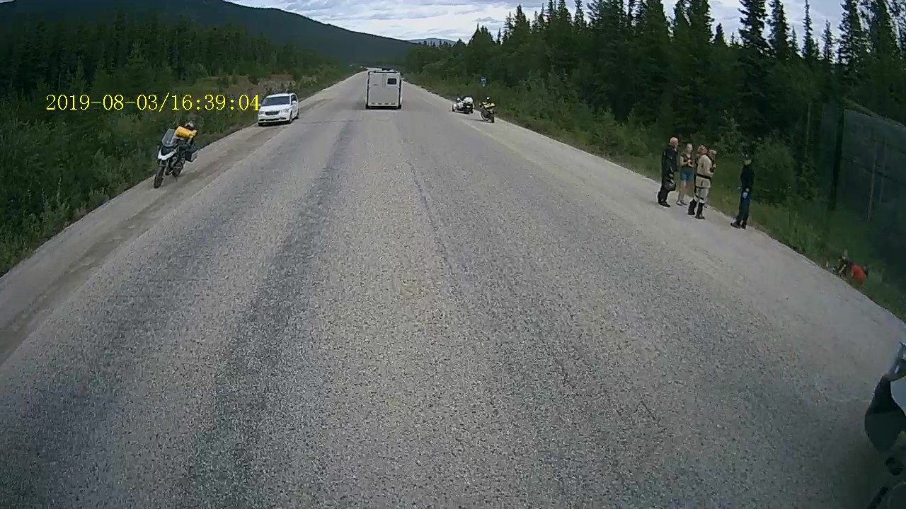
Neither Debbie or I checked to see if we had cell phone coverage, but based on the area, I suspect that there was not. About 50 miles further east, about the time we reached Junction 37, an ambulance sped by going west with lights and siren. Shortly after that what appeared to be a fire rescue vehicle sped by with emergency equipment on. These two were followed yet another fire rescue vehicle and shortly after a RCMP vehicle. Hopefully it was not the accident that we had passed more than an hour before.
We passed by Junction 37 and continued into Watson Lake, YT and fuelled up. We then returned to Junction 37, where there is a minimally maintained RV Park. We secured a spot and settled in for the night. The RV area looks to have been well laid out. It contains two circles with back in spots that have water and electric and some with sewer. Then there are about 12 pull through sites that are full service, then there are another 12 or so sites that have been created as pull through and never fully developed with power, water and sewer. About $750K and you could have a thriving RV Park.


 |
| This map shows the area that we will travel - From the "You are here" to Prince George. We previously did the Dawson Creek to Watson Lake leg. |
No comments:
Post a Comment