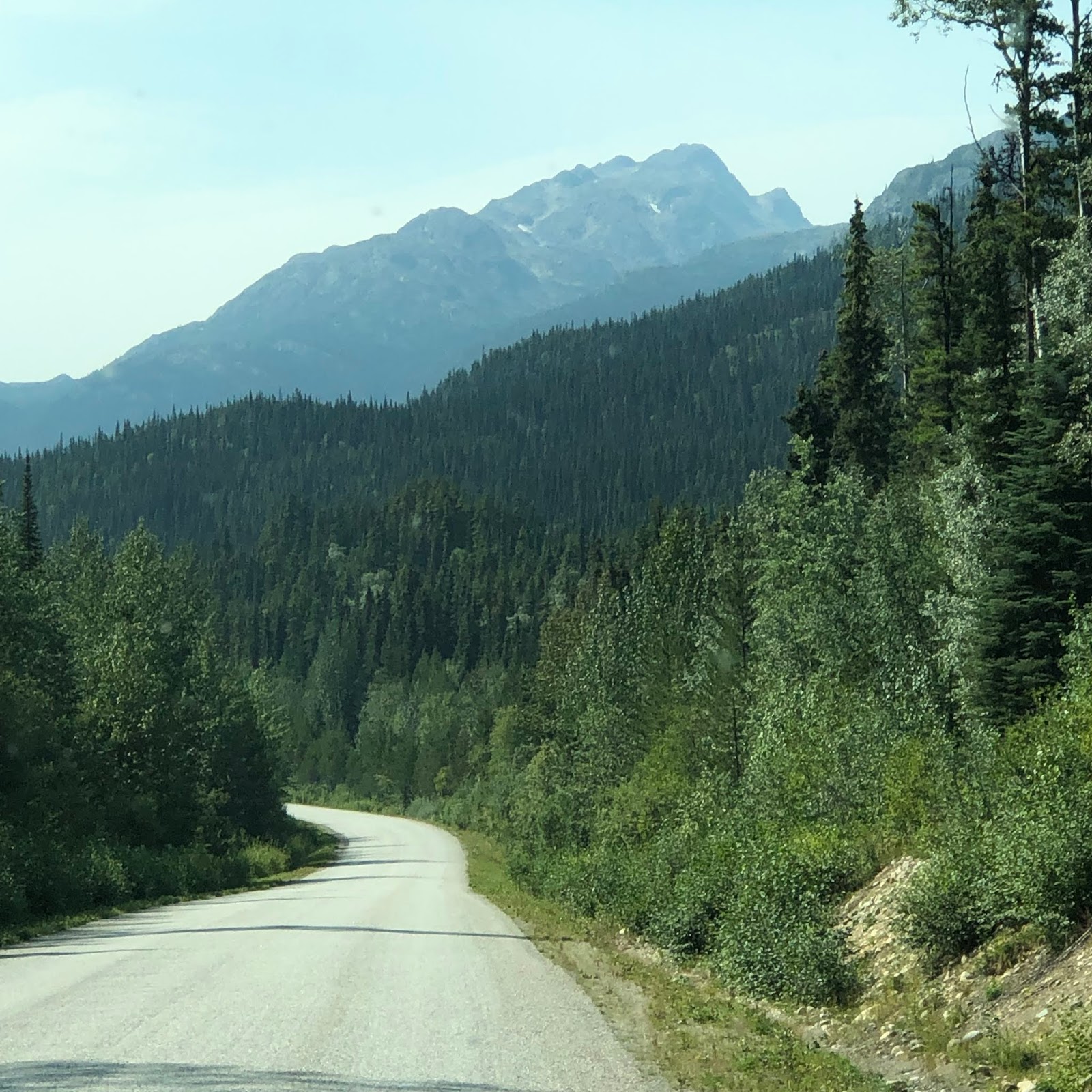
After a slow start, we were on the road about 10:30. Tanks dumped and fresh water filled. Dease Lake was our next stop. Canada 37, also known as the Cassiar Highway or the Alaska-Stewart Highway, is a two lane road. Right where you cross from the Yukon Territory into British Columbia, the road had recently been chip coated and there are no centerline and no fog lines. Of course the fog lines on this road would be right on the very edge as it is narrow. Not as narrow as say going through Cooper Landing on Alaska 1 going to Homer. But narrow.
This road winds through the Stikine Range of the Cassiar Mountains. The straight sections of roadway are far out numbered by the curves. The speed limit is set at 80KPH, or about 50MPH. We found that the best speed was about 45MPH. This made the 170+ mile drive seem long. We arrived at our destination, Waters Edge Campground before 2PM, so less than a four hour drive. This short drive will pale to the 250 miles on this same road tomorrow.


Along this highway, we passed Jade City, B.C. This is a very popular place for people to stop and get Jade of all kinds. As you will see in the photos, it was pretty crowded. The region around Jade City is rich with serpentinite, greenstone, and Nephrite Jade. 90% of Jade in the world comes from the Cassiar Mountains. (Thanks Wikipedia)


Waters Edge is a completely dry camp with no water, power or septic. We knew this coming in, and though it is close to boondocking, with boondocking you can usually run your generator whenever you want, where here the turn off time is 10PM. Energy savings measures will be in place to make sure that the batteries do not run out.
The owners, Chuck and Gracie Phillips, who appear to be in the mid to late 70s, first put a road into this property in 2000.

Then it was a few years before they put their trailer on it and they have been building it out little by little.


From our conversation, it appears there is no intention of adding electrical or water to the sites. Just that could turn this into a gold mine. They have a very nice concrete boat launch and a gravel/soil berm for a pier. They choose the locations of the sites well and made many with a view of the lake. They constructed others as pull throughs for larger vehicles. About 24-25 spaces in all. I asked Chuck if they lived here year round, and he said no, they use to live in the town site (Dease Lake), but now spend the winter in southern California where they have a trailer. They advertise limited WiFi, but they are having equipment problems today and could not provide that.
No air conditioning after 10 pm - Temperature outside is in the mid 70s outside and mid 80's inside - a cool breeze is keeping things in check for now
From Dease Lake, on August 5, we continued our travel south on Highway 37. The road continues with no centerline and no fog lines. The pavement narrows then widens and then you get that 20 mph hairpin turn on gravel.
The road continues through the Stikine Range of the Cassiar Mountains. Travelling along ridgelines and across and along the Stikine River. (Looks like the windshield did not get cleaned the night before)


We slowly made progress down this road, stopping in Kluachon to top off the fuel tank.

Once we got past Kluachon the road had a centerline and seemed to widen out. It is amazing how just a centerline will increase the road width in your mind.
Down the road aways we stopped to let the dog out. Our stopping point just happened to be next to the Bob Quinn Airport. The airport was constructed to allow access to the mineral wealth of the area.

While we were there, we did see helicopter traffic at the airport.

Another interesting little bit of information is that a majority of Highway 37 parallels the Telegraph Trail. This trail ran the length of a Telegraph Line installed in the 1860s and re established in the 1899 to 1901 timeframe. The Telegraph line ran from Ashcroft, B.C. to Dawson City, YT. Along the trail were cabins located from 25-40 Kilometers apart. Much of the trail is now overgrown.
We were lucky to see two bears. One crossed from the left to the right and the other stayed on the left shoulder.


About 10 minutes later a Cow Moose and her Calf crossed the road for the left side to the right side.


Pretty amazing.
At the junction of Highway 37 and 37a, we turned west and followed Highway 37a toward Stewart, BC and Hyder, AK. This road share the same characteristics of Highway 37.


Along the way we were lucky to see another bear. This one on the left side of the road and larger than the first two.


It is paved, two lane with shoulders of varying width. The road follows Lake Meziadin then picks up a river. It hugs the cliffs along the river through several landslide and avalanche areas before crossing the foot of Bear Glacier.


Of course, if you have a glacier, then you have water - lots of water, raging rivers, streams and waterfalls.


Then the road drops down and at some points has water flowing on both sides. Some very dramatic waterfalls were passed along the way.
Finally, we enter Stewart, BC. We had been told by the RV Park we were staying at that we would not have dump facilities and were told that the City of Steward did have a free sanitary dump station. Thinking it would be at the Municipal Park, we followed the signs, arrived there - Rainey Creek Camp. I went in to ask about the dump station, was told that they did not have one. I was given directions to the Municipal Sanitary Dump Station. The person at the RV Park stated that the best places to eat were in Hyder, AK - the Fish Bus and the Glacier Inn.
After turning around, we found the Sanitary Dump Station in Stewart, emptied the tanks and then headed to Hyder, AK. The two towns are separated by the Portland Ship Canal, sort of.
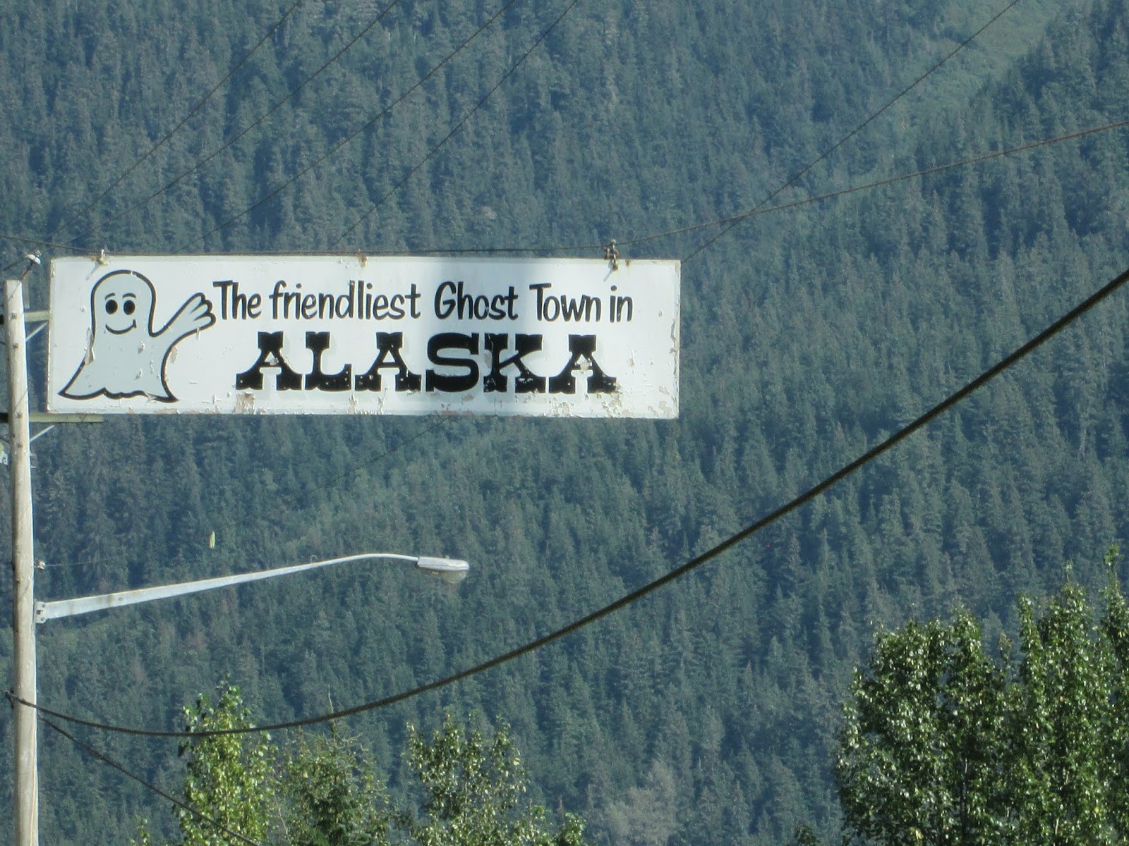
Once you cross the canal you are in Hyder, AK and a main street has about six buildings (Ok, maybe nine) along it. Hyder bills itself as the friendliest Ghost Town around. We followed this down and "out" of town and arrived at Camp Run-a-Muck. These three videos show the trip through part of Stewart, B.C. and then through Hyder, AK to the RV Park. Gives you an idea of the two towns.

This Campground is in a wooded setting, with some of the sites in the trees and others are out in the open. We took a FH (full hookup) site, which we pulled forward into. Our view was of forested greenery. The Salmon River was less than 30 yards away, but due to the brush, you could not see the river. It was quiet.

The campground is located right across from the Brookside Baptist Church. Don't know how large this congregation is, don't think there are a thousand people in the entire area.

After getting set-up we decided that we should check out the two dinner options mentioned by the attendant at the Rainey Creek RV Park. The first was a drive by the Fish Bus. It appeared to have outdoor seating, and had a line of people and lots of cars around it. we continued on to find that the Glacier Inn was closed on Mondays. So, back to the Fish Bus Celebrates 20 years
We parked, got in line and noticed a Texas licensed vehicle parked near the restaurant. I walked around a bit and found that there was indoor seating in the back of the bus. Picnic tables where you sat with other people. We placed our order, Halibut Fish and Chips. This is a one person operation. The owner does it all, one order at a time. After placing the order, we went into the back indoor seating area and immediately got into a conversation with the couple from Merkle, TX. There was one other couple in there and a group of four people. The other couple, the couple from Merkle and Debbie and I got into a conversation about where we had been in Alaska and where we were headed. It came to the topic of roads and everyone agreed that the road from Tok to Whitehorse was the worst road. The second was the road from Glenallen to Tok and from Valdez to Glenallen.
I went back to the front of the Fish Bus to listen for our name to be called. The woman from Merkle also came out and we continued to talk about our trip through Alaska. We were joined by a gentleman who was on a motorcycle. He had started out from Chicago and still had a few more thousand miles to go. From Hyder he was going to take a ferry to the north end of Vancouver Island, travel the Island on his motorcycle, and then catch a ferry from Vancouver BC to Port Angeles and then continue his travels.
Our order came up and it was the best Halibut Fish and Chips so far.

After dinner back to the Motor Home for the night.
Today, August 6 is a tale of two glaciers, waterfalls and the search for bears. We started the day by going to the Salmon Glacier. This is the fifth largest glacier in North America. To get to the view-point we were told that it was just up the road about 10-15 miles. OK, not bad. We were warned that the road had potholes. Still, no problem. The road starts with about five miles of paved road that goes to the Fish Creek Bear Viewing Area. This location is operated by the US Forest Service. Shortly past that, the road turns to gravel. As the miles go by the road gets worse and yes there were potholes. You try to avoid one and you hit three. And the road climbs. going from sea level to about 4,300 feet in the twenty two miles of road. As you go, the road hugs cliffs, provides some great waterfall photo opportunities, goes to single lane over slide areas and climbs.


The first view-point of the glacier is called the Toe of the Glacier. It is about five or six miles from the main portion. A beautiful sight.


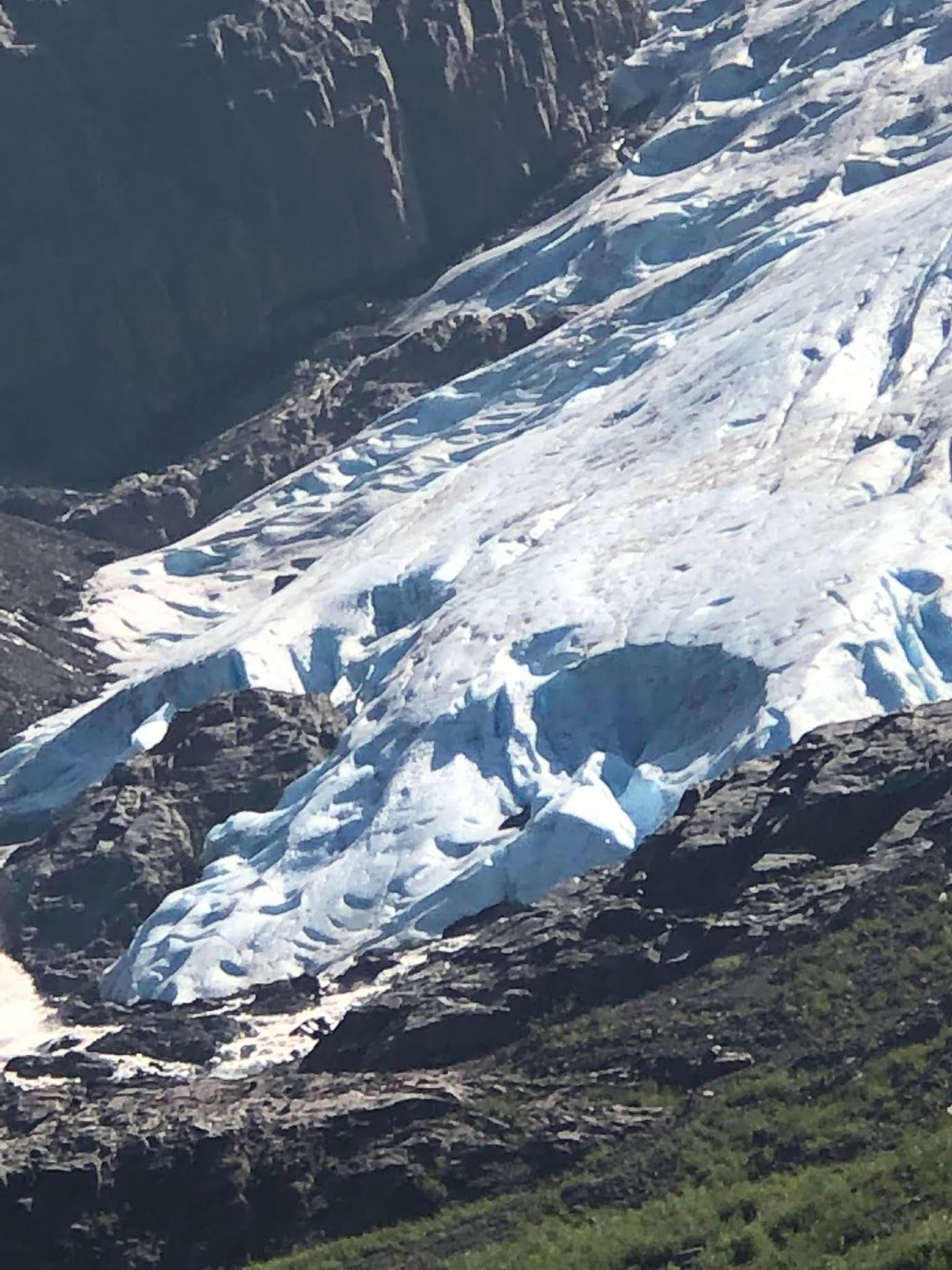
Continuing on, you reach the main view point where you can see the vastness of the glacier. As one gentleman, who sells postcards at the view point, stated, it is the only glacier you can look down on and up at in the same location. As the glacier comes down the mountain, it turns to the right (the viewers left) and continues down the canyon.


 |
| Surface of the glacier. Captured with telephoto lens |


After multiple photos, we journeyed back down the hill. It was interesting the amount of gold mining that is still underway in the Hyder area. More modern now, using helicopters with specialized equipment to determine where gold might be.


After a stop at the Motor Home, it was off to see the other glacier, Bear Glacier - the one alongside Highway 37a. First, we toured the Hyder dock area,


drove through downtown Hyder, (interesting fact, Hyder was originally to be named Portland City when the boom hit in 1910. In 1914 when applying for a Post Office, the US Postal Service rejected the name and the residents changed the town name to Hyder. Hyder was the name of a mining engineer and geologist who had visited the year before and gave positive results.)


then we stopped at the Canadian Border and showed our passports, answer the usual questions and be on our way.


On the way out to Bear Glacier we decided to stop and peruse the town of Stewart. This town, unlike Hyder, has more businesses. There is a hardware store, a fuel station that has some tire service, a grocery store or two and the usual tourist stores.


Most everything recognizes the relationship between the two towns, in different countries.
Heading east on Highway 37a, we stopped and took pictures of many waterfalls and of raging rivers.


At Bear Glacier we took several pictures. This glacier is not near as dramatic or as large as Salmon Glacier.


On the return home we decided to stop for dinner at the other recommended eating establishment. The Glacier Inn. The building was built in 1920 and became a bar/lounge in 1956.


Dinner was - you guessed it - Halibut Fish and Chips and a Halibut Sandwich. For dessert it was take-out Carrot Cake and Chocolate/Cherry Cake.


Around the walls are stapled US and Canadian currency with the names and dates of the people who have visited that restaurant. We added our one dollar US bill with our name and date on it. The currency is all stapled to plywood panels, that once filled are hung from the ceiling.


After stopping to take the dog for a walk - we went back up the road to the Fish Creek Bear Viewing area. This consists of a wooden boardwalk along Fish Creek.

The creek and a small connected lagoon is a large spawning creek for Red and Chum Salmon. Because there are so many fish and the water is shallow it is also a favorite place for bears to go fishing. This year we found out, there was a great return of Salmon, but not a great return of bears. It is thought that the bears are fishing below the viewing area. We were there for about 90 minutes and did not see a bear.


We talked to others that had been coming out regularly for years and never saw any bears. Well, we saw three on the highway - that counts.
